
Villarrica
Villarrica, also known as Ruka Pillañ in Mapudungun, is one of Chile's most active volcanoes, recognized for its intermittent lava lake. Situated in Villarrica National Park, it is a significant stratovolcano with a history of strombolian eruptions and lahars, making it a subject of both scientific monitoring and popular tourism for guided ascents.
Key Facts
- ›Villarrica is a stratovolcano located in Villarrica National Park, Chile.
- ›It is known for having an active, though intermittent, lava lake within its crater.
- ›The volcano typically produces strombolian eruptions, ejecting incandescent pyroclasts and lava flows.
- ›Rainfall combined with melted snow and glacier ice can trigger massive lahars.
- ›It is one of 9 volcanoes monitored by the Deep Earth Carbon Degassing Project for CO2 and SO2 emissions.
- ›Guided ascents are popular during the summer months.

VolcáN Villarrica, Ruka Pillañ, RucapilláN
- the Mapuche People Refer To It As Ruka Pillañ, Meaning 'Great Spirit's House' Or 'the Demon's House'.
- Some Mapuches Have Historically Attributed Volcanic Disasters To the Actions of Settlers Or Believed Nature Was Allied With Them.
- the Volcano's Activity Has Historically Influenced the Settlement Patterns and Economy of the Region, Such As the Relocation of the City of Villarrica Due To Lahar Hazards.
About Villarrica
Villarrica, known in Mapudungun as Ruka Pillañ or Rucapillán, translating to 'great spirit's house' or 'the demon's house,' is a prominent and highly active stratovolcano in southern Chile. It is a significant natural landmark, rising above the lake and town of the same name, approximately 750 km south of Santiago. As one of the westernmost of three large stratovolcanoes aligned along the Mocha-Villarrica Fault Zone, Villarrica is protected within Villarrica National Park.
Geological Activity and Features
This volcano is distinguished by its basaltic-andesitic lava composition and is one of the few volcanoes globally known to host an active, albeit intermittent, lava lake within its crater. Its eruptions are typically strombolian, characterized by the ejection of incandescent pyroclasts and lava flows. A significant hazard associated with Villarrica is its potential to generate massive lahars, which are mud and debris flows, when rainfall combines with melted snow and glacier ice, as evidenced by devastating events in 1964 and 1971. The volcano is also a subject of ongoing scientific study, being one of nine monitored by the Deep Earth Carbon Degassing Project for its carbon dioxide and sulfur dioxide emission rates.
Historical and Cultural Context
Eruptive activity has been documented since the mid-16th century, influencing the region's history and settlement. Historical accounts suggest that lahars from mid-16th century eruptions may have buried gold placers, prompting the Spanish settlers to relocate the city of Villarrica to its current, less hazardous site. The volcano holds cultural significance for the indigenous Mapuche people, who have traditional beliefs and interpretations regarding its power and influence.
Tourism and Accessibility
Villarrica is a popular destination for adventurers and tourists. Guided ascents to the crater are a common activity, particularly during the summer months, although these can be suspended due to volcanic activity or weather conditions. In winter, the northern slopes host a ski resort. Helicopter over-flights have also been available since 2007, offering a different perspective of the volcano's grandeur.
Source: Wikipedia ↗
Frequently Asked Questions
What is Villarrica known for?
Villarrica is known as one of Chile's most active volcanoes. It is particularly recognized for its intermittent lava lake within its crater and its strombolian eruptions which can produce lava flows and incandescent pyroclasts.
What are the geological features of Villarrica?
Villarrica is a stratovolcano with a basaltic-andesitic lava composition. It covers an area of 400 km² and has an estimated volume of 250 km³, containing volcanic caves and scoria cones. Its current edifice grew after two significant collapses forming calderas in the Middle Pleistocene and 13,700 years ago.
What are the risks associated with Villarrica's eruptions?
Eruptions can cause lahars, which are massive mud and debris flows, triggered by rainfall and melted snow or glacier ice. Toxic sulphurous gases can also be released, making the air unbreathable in nearby areas.
Is Villarrica a popular tourist destination?
Yes, Villarrica is popular for climbing, with guided hikes to the crater offered from the town of Pucón. A ski resort also operates on its northern slopes during the winter months.
What is the historical significance of Villarrica's eruptions?
Eruptions have been recorded since the 16th century and have influenced the region. For example, lahars associated with mid-16th century eruptions may have buried gold placers, prompting the relocation of the city of Villarrica.
Related Sacred Mountains

Machu Picchu
Machu Picchu is a 15th-century Inca citadel situated on a mountain ridge in southern Peru, standing as a significant symbol of the Inca civilization. Believed to have been an estate for Emperor Pachacuti, the site was likely abandoned around the time of the Spanish conquest, with modern dating placing its occupation between the early 15th and early 16th centuries. It is renowned for its classical Inca architecture, including finely crafted dry-stone walls and notable structures like the Temple of the Sun.
Aconcagua
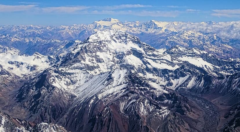
Aconcagua is the highest mountain in the Americas, located in Mendoza Province, Argentina. It is also the highest peak outside of Asia and the second-most topographically prominent peak globally. Formed by tectonic activity, it was once an active stratovolcano and is now a significant challenge for mountaineers due to its extreme altitude, despite its technically straightforward normal route.

Mount Roraima
Mount Roraima is the highest tepui in the Pacaraima mountain chain, straddling the borders of Brazil, Guyana, and Venezuela. Known for its dramatic sheer cliffs and flat summit, it is a unique geological formation that has fostered a high degree of endemic flora and fauna due to its isolation. The mountain's name originates from the Pemon people, meaning "blue-green great," reflecting its natural beauty.