
Takht-e-Sulaiman
Takht-e-Sulaiman, meaning 'Throne of Solomon,' is a prominent peak in the Sulaiman Mountains of Pakistan's Khyber Pakhtunkhwa province. It holds significant mythological importance, with legends attributing its name to Prophet Solomon and Pashtun mythology identifying it as the burial place of their ancestor, Qais Abdur Rashid. The mountain is characterized by its olive groves and pine-nut forests, and is known for its diverse wildlife.
Key Facts
- ›Located in the Sulaiman Mountains, near Darazinda in Khyber Pakhtunkhwa, Pakistan.
- ›Its highest elevation is 3,487 meters (11,440 ft), making it the tallest peak in Dera Ismail Khan District.
- ›Named 'Throne of Solomon' after a legend of Prophet Solomon viewing Hindustan from its summit.
- ›Known locally in Pashto as Da Kasī Ghar ('Mountain of Qais'), believed to be the burial site of Pashtun ancestor Qais Abdur Rashid.
- ›The mountain is surrounded by olive groves and pine-nut forests.
- ›Hosts various wild animals including markhors, wolves, and eagles.
KōH-E SulaymāN, Da Kasī Ghar
Islam, Pashtun Mythology
- Associated With Prophet Solomon's Legendary Observation of Hindustan.
- Considered the Burial Site of Qais Abdur Rashid, the Legendary Ancestor of the Pashtun People.
Prophet Solomon, Qais Abdur Rashid
About Takht-e-Sulaiman
Takht-e-Sulaiman, a name that translates to 'Throne of Solomon,' is a significant peak within the Sulaiman Mountains of Pakistan. Located near Darazinda in Khyber Pakhtunkhwa province, it is the highest mountain in the Dera Ismail Khan District, reaching an elevation of 3,487 meters (11,440 ft).
Mythological and Spiritual Significance
The mountain is deeply embedded in local mythology and spiritual traditions. The name 'Throne of Solomon' originates from a legend recorded by Ibn Battuta, which recounts Prophet Solomon climbing the peak and gazing upon the land of Hindustan, then shrouded in darkness. According to Pashtun folklore, the mountain is also the burial site of Qais Abdur Rashid, the revered legendary ancestor of the Pashtun people. This belief gives the peak its local Pashto name, Da Kasī Ghar, meaning 'Mountain of Qais.'
Natural Environment
Takht-e-Sulaiman is notable for its natural beauty, being surrounded by lush olive groves and productive pine-nut (chalghoza) forests. The area serves as a habitat for a variety of wildlife, including markhors, wolves, rabbits, eagles, and partridges. The region has also been known as a hunting ground for royalty from Gulf Arab states, who pursue precious birds.
Location and Geography
The mountain is situated in the Dera Ismail Khan Subdivision of Khyber Pakhtunkhwa and lies close to the borders of South Waziristan and Zhob in Balochistan. Its prominence as the highest peak in Dera Ismail Khan District underscores its geographical importance in the region.
Source: Wikipedia ↗
Frequently Asked Questions
What is the meaning of Takht-e-Sulaiman?
Takht-e-Sulaiman literally translates to 'Throne of Solomon.' This name is derived from a legend associated with Prophet Solomon.
What is the local Pashto name for Takht-e-Sulaiman and why?
The local Pashto name for the mountain is Da Kasī Ghar, which means 'Mountain of Qais.' This name stems from Pashtun mythology, which states that Qais Abdur Rashid, the legendary ancestor of the Pashtun people, is buried on its summit.
What is the elevation of Takht-e-Sulaiman?
Takht-e-Sulaiman reaches an elevation of 3,487 meters (11,440 ft). This makes it the highest peak within the Dera Ismail Khan District.
What kind of environment can be found around Takht-e-Sulaiman?
The mountain is characterized by its natural surroundings, including extensive olive groves and pine-nut (chalghoza) forests. It also supports a variety of wildlife.
Related Sacred Mountains

Mount Terich Mir
Mount Terich Mir is the highest peak in the Hindu Kush range, standing as the 33rd highest mountain globally and the tallest outside the Himalayas–Karakoram. Located in the Chitral District of Pakistan, it is a significant landmark visible from the town of Chitral and holds deep spiritual and mythological importance for local communities, including the Kalash and Chitrali people.

Mount Diamer
Nanga Parbat, also known by its Shina name Diamer, is the ninth-highest mountain on Earth, reaching an elevation of 8,126 meters (26,660 ft). It is situated in the Gilgit-Baltistan region of Pakistan and serves as the western anchor of the Himalayas. Renowned for its extreme difficulty and high climber fatality rate, it has earned the ominous nickname "Killer Mountain."
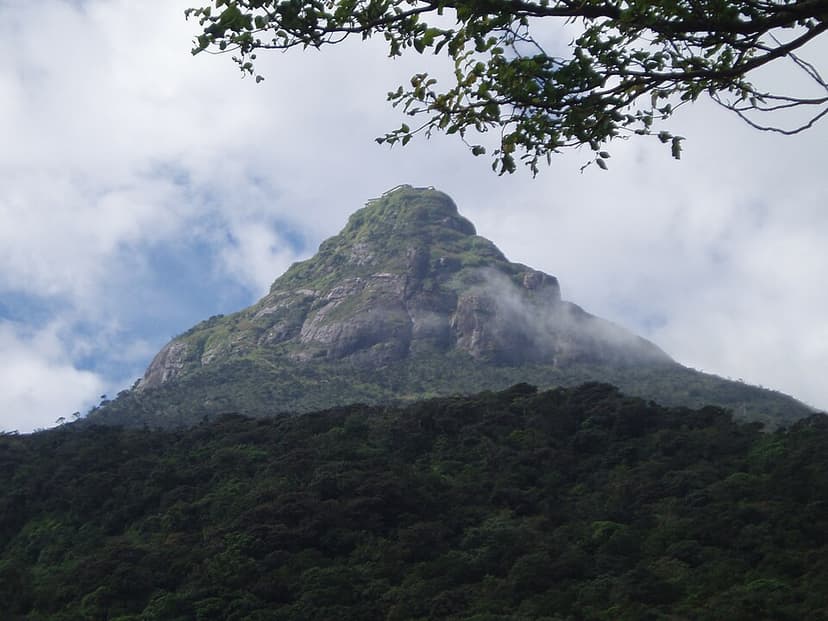
Adam's Peak
Adam's Peak, also known as Sri Pada, is a 2,243-meter-tall conical mountain in central Sri Lanka famed for a sacred footprint-shaped rock formation near its summit. This "sacred footprint" is revered by Buddhists as the Buddha's, by Hindus as Shiva's or Hanuman's, and by some Islamic and Christian traditions as Adam's or St. Thomas the Apostle's, making it a significant pilgrimage site for multiple faiths.