
Balapokuna Raja Maha Vihara
Balapokuna Raja Maha Vihara is a historic Buddhist temple located in Pamankada, Sri Lanka, near the Colombo-Batticaloa main road. It is recognized by the government as an archaeological site, with its name originating from a natural pond on its premises, historically known as "Batapokuna" and linked to King Parakramabahu VI. Popular legend associates the pond with an ancient tunnel system connecting to Kotte.
Key Facts
- ›The temple is situated in Pamankada, Western Province, Sri Lanka.
- ›It is recognized as an archaeological site by the Sri Lankan government, officially designated on June 6, 2008.
- ›Its name, Balapokuna, derives from a natural pond within the temple grounds.
- ›The pond was historically called "Batapokuna" and its water was used by soldiers during the reign of King Parakramabahu VI.
- ›Local legend suggests the pond is an entrance to an ancient tunnel system originating from Kotte.
- ›The temple is located near the 6th mile post junction on the Colombo-Batticaloa main road.

Important Relationships
- King Parakramabahu VI
Natural Pond, Ancient Tunnel System
- Designated As An Archaeological Site By the Sri Lankan Government On June 6, 2008.
About Balapokuna Raja Maha Vihara
Balapokuna Raja Maha Vihara is a significant Buddhist temple located in Pamankada, within the Western Province of Sri Lanka. Its strategic position near the 6th mile post junction on the Colombo-Batticaloa main road places it in a historically accessible area. The temple holds formal recognition from the Sri Lankan government as an archaeological site, a designation officially made on June 6, 2008, under government Gazette number 1553.
Naming and Legend
The temple derives its name from a natural pond situated within its premises, known as 'Balapokuna'. This pond was historically referred to as 'Batapokuna', a name originating from the Sinhalese word 'Bata', meaning soldiers. Popular legend recounts that during the reign of King Parakramabahu VI, the water from this pond was utilized by his soldiers. Over time, the name 'Batapokuna' gradually evolved into its current form, 'Balapokuna'.
Further adding to its mystique, Balapokuna is popularly believed to be an exit point for an ancient tunnel system. According to local lore, this tunnel connects to Kotte, with other purported access points at Kotte Ananda Shastralaya and Pita Kotte Gal Ambalama. While the exact historical veracity of these tunnels remains a subject of legend, they contribute to the temple's rich narrative and historical intrigue.
Source: Wikipedia ↗
Frequently Asked Questions
Where is Balapokuna Raja Maha Vihara located?
Balapokuna Raja Maha Vihara is located in Pamankada, Western Province, Sri Lanka. It is situated near the 6th mile post junction on the Colombo-Batticaloa main road.
What is the origin of the name Balapokuna?
The temple is named after 'Balapokuna', a natural pond found on a rock surface within its premises. This pond was formerly known as 'Batapokuna', derived from the Sinhalese word 'Bata' meaning soldiers.
What is the historical significance of the Balapokuna pond?
According to historical accounts, the water from the pond was used by soldiers during the reign of King Parakramabahu VI. Popular legend also claims it is an exit point for an ancient tunnel connecting to Kotte.
Is Balapokuna Raja Maha Vihara an officially recognized site?
Yes, Balapokuna Raja Maha Vihara has been formally recognized by the Government of Sri Lanka as an archaeological site. This designation was officially declared on June 6, 2008.
Related Buddhist Temples

Abhayathilakarathnaramaya
Abhayathilakarathnaramaya, also known as Kuruvita Purana Vihara, is an ancient Buddhist temple situated in Kuruwita, Sri Lanka. It holds significance as a formally recognized archaeological site by the Sri Lankan government, highlighting its historical and cultural importance.
Adashino Nenbutsu-ji
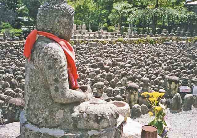
Adashino Nenbutsu-ji is a Buddhist temple in Kyoto, Japan, historically situated in an area where the bodies of the deceased were abandoned. Founded as a temple by Kūkai in 811 and later altered by Hōnen, it now houses approximately eight thousand Buddhist statuettes that memorialize the souls of the dead. The temple is particularly known for its 'sento kuyo' ceremony, where thousands of stone statues are illuminated with candles.
Abhayagiriya
Abhayagiriya Vihāra was a prominent Buddhist monastic complex and a royal capital in Anuradhapura, Sri Lanka, historically serving as a major center for Theravada, Mahayana, and Vajrayana Buddhism. It was a significant religious and educational institution, attracting scholars from afar and playing a crucial role in the spread of Buddhism internationally, making it a vital pilgrimage site.